In 1864, Jules Verne’s “Journey to the Centre of the Earth” allowed unchecked imagination to roam free. At that time, so little was understood about our planet’s interior that any fantastical notion seemed plausible. Today, however, the exploration of Earth’s subsurface has profoundly shifted focus. It is now a critical area in the pursuit of new energy resources and holds vital importance for climate initiatives like carbon capture and storage. Consequently, vast resources are currently allocated to achieving an ever more detailed comprehension of what lies beneath us.
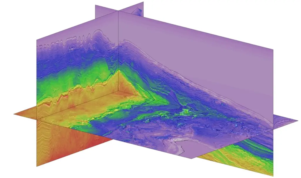
For scientists and engineers, this endeavor presents a challenge that is as captivating as it is demanding. Gordon Poole, UK Research Manager for Viridien, a geoscience data and technology company formerly known as CGG, explains the process: “We transform raw seismic measurements into 3D images of the Earth.” These visualizations reside within computers, and the core challenge lies in achieving the highest possible resolution for these subterranean representations.
Illuminating Hidden Layers
For over a century, physicists have been diligently working to extract the planet’s secrets. Initial methods involved using explosions to generate signals that penetrated the Earth’s crust. “We employ various methods to create sound waves at the surface,” Poole notes. “The resulting wavefront travels through the Earth, and a portion of its energy is reflected back.” By analyzing these echoes, geophysicists can ascertain the characteristics of the rock formations through which the sound waves have propagated.
For many years, a significant amount of information within the recorded signals was disregarded to maintain manageable algorithm complexity. This changed in 1984 when physicist Albert Tarantola introduced “full-waveform inversion” (FWI). This technique significantly enhances data analysis by processing every distortion a wave encounters. These distortions include not only refractions and multiple reflections but also elastic effects and subsurface anisotropy, where rock properties vary depending on the direction of wave propagation.
Poole emphasizes that the “inversion” aspect of this technique is particularly transformative. “We are essentially reverse-engineering the processes occurring within the Earth.” The process begins with geophysicists constructing a computer simulation. This model dictates how subterranean structures would reflect, refract, and distort a signal originating from the surface, incorporating all identifiable wave components. These digital predictions are then rigorously compared against the real-world signals captured by their instruments. Subsequently, adjustments are made to the simulated subterranean structures, and the process is repeated. The point at which the simulated and real-world signals converge signifies the creation of a highly accurate simulation of the subsurface structures under examination.
Full-waveform inversion has revolutionized the discovery of fossil fuel reserves. Crucially, it is also indispensable for imaging the rock formations suitable for storing carbon captured from fossil fuel processing and challenging industrial processes. The United Nations and other international bodies recognize carbon capture and storage as an essential component of global strategies to combat climate change. However, it is imperative to have a thorough understanding of these storage systems. “After carbon dioxide has been injected, we must confirm that it remains where it is intended to be,” Poole states.
Cutting-Edge Scientific Applications
This is where another advanced technique, distributed acoustic sensing (DAS), proves invaluable. DAS utilizes underground optical fiber cables to detect minute external vibrations. Malcolm Kent, Viridien’s Global Head of Carbon Storage, explains that “external events can cause distortions in the cable.” These distortions impact the light passing through the fiber, thereby revealing nearby subterranean activity. “Our primary objective is to create a 3D representation of the subsurface extending away from the fiber optic cable itself,” he adds.
Effectively, DAS transforms a standard optical fiber into an extensive, continuous array of sensors. These sensors measure the ambient seismic waves generated by natural phenomena such as earthquakes and ocean movements, as well as human activities like transportation. This provides a high-resolution depiction of subsurface composition, structure, and evolving conditions over time. Engineers can leverage existing fiber optic infrastructure, such as subsea internet cables, or deploy new cables in locations most relevant to their objectives, such as within oil wells.
The potential impact of DAS on carbon dioxide storage is considerable. This technology can facilitate long-term monitoring of storage sites, ensuring that conditions do not change in ways that might permit carbon dioxide leakage. This approach strikes a necessary balance between regulatory reporting mandates and the need for cost-effective solutions.
A key factor in Viridien’s success has been its capacity to build upon advancements in data analysis and acquisition, supported by its substantial computing power, as detailed in the accompanying box.
Delivering Innovation Through Computing Power
The advent of high-performance computing has ushered in a new era of technological advancement. “As computing capabilities expand, we are empowered to pursue what our teams excel at: addressing the most complex data challenges and objectives,” Kent observes. “We take pride in attracting exceptional talent, but equally, we ensure they possess the necessary tools to undertake highly sophisticated projects.”
“Our drive in understanding the Earth is to continuously approach a more precise representation of reality,” Poole adds. In essence, this represents a modern iteration of Verne’s journey to the planet’s core, a feat he would likely find impressive.
The Petaflop Advantage
The sophisticated advancements in FWI and DAS are contingent upon access to immense computational resources. This necessity underpins Viridien’s investment in developing its own large-scale, highly customized, high-performance computing facilities. “Prior to the emergence of AI, seismic imaging was one of the most significant consumers of industrial high-performance computing,” Poole states. “Viridien commands 700 petaflops of computational power, meticulously optimized for seismic imaging tasks.”
This capacity firmly establishes Viridien as a significant player in the field of scientific computing. More recently, the company has reinforced its commitment to efficiency and environmentally conscious supercomputing, further reducing its carbon footprint. This strategic focus enables Viridien to offer results-oriented computing services, where clients are billed for the quality of the seismic image or data insight delivered, rather than for processor uptime.
Viridien’s infrastructure has positioned it as a crucial collaborator for academic institutions. Romain Brossier from the University of Grenoble notes, “We can spearhead certain projects, but only those involving problems of a limited scale.” This limitation is defined by the frequency capabilities of FWI; academic resources typically manage frequencies up to approximately 25 Hz, according to Brossier. “With Viridien’s computational power, they can operate at frequencies approaching 120 Hz,” he elaborates. “The ability to utilize a frequency five times higher translates to five times greater detail.”
For further information, visit: viridiengroup.com