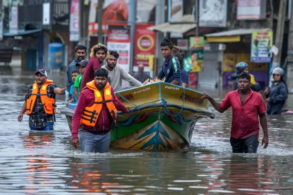
A significant oversight in almost all research concerning the impacts of future sea-level rise has been identified: the assumption that current sea levels are lower than they actually are. This “methodological blind spot” means that coastal flooding and erosion are likely to manifest sooner than previously anticipated.
Katharina Seeger and Philip Minderhoud, researchers at Wageningen University in the Netherlands, conducted an analysis of 385 peer-reviewed studies focused on coastal vulnerability. Their findings revealed that a staggering 90 percent of these studies failed to incorporate the influence of factors such as ocean currents, tides, water temperature, salinity, and prevailing winds on sea level. Consequently, these studies underestimated the actual water level at coastlines by an average of 24 to 27 centimeters.
Implications for Population Displacement and Vulnerability
Adjusting for this methodological gap could lead to a substantial increase in the projected number of people whose homes will be submerged by the year 2100. Estimates suggest this figure could rise by up to 68 percent, translating to an additional 132 million individuals facing displacement. The majority of this impacted population resides in Southeast Asia and Oceania. In these regions, sea levels are now understood to be, on average, approximately 1 meter higher than previously calculated, with certain areas experiencing even higher discrepancies of several meters.
Philip Minderhoud commented on the implications of such miscalculations during a briefing. He stated, “If a representative from a place like that comes to a global gathering and tries to gather support… it can be quite frustrating if there’s this type of scientific assessment that actually says… it will only be affected in the next century, while in reality the area is actually much more exposed.”
While projections indicating a potential sea-level rise of up to 1 meter by the end of the century remain valid, the timing of their consequences has been significantly altered. The research indicates that because the foundation of most analyses on the effects of this rise was based on an erroneously low baseline sea level, the predicted impacts will occur more rapidly than originally forecasted.
Influence on Intergovernmental Panel on Climate Change Reports
The studies examined by Seeger and Minderhoud have had a notable influence on broader climate assessments. Specifically, forty-six of these analyzed studies were cited in the most recent reports by the Intergovernmental Panel on Climate Change (IPCC). The IPCC’s reports are widely recognized as the most authoritative statements on the effects of global warming, including phenomena like sea-level rise.
Understanding Geoid and Actual Sea Level
The Earth’s rotation causes it to bulge at the equator. Furthermore, denser regions within the planet’s mantle exert a stronger gravitational pull on the water above them. To accurately determine the elevation of any given location, a computer model of the geoid is necessary. The geoid is an irregular shape that represents the mean sea level across the globe.
However, the actual sea level can deviate significantly from the geoid. In areas where winds or ocean currents cause water to accumulate, or where warmer temperatures lead to water expansion, sea levels can be several meters higher. Additionally, coastlines themselves are subject to change, with river sediment deposition or groundwater extraction by urban centers potentially causing upward or downward shifts in land elevation.
Shortcomings in Research Methodologies
Instead of determining land and water elevations at coastlines by cross-referencing satellite measurements with the geoid, the overwhelming majority of researchers opted to use the unadjusted geoid sea level. Even among those who did perform calculations, errors were common. These mistakes often stemmed from using different geoid models to determine land and sea elevations. The analysis indicated that less than 1 percent of the reviewed studies accurately determined the current sea level for the coastlines under investigation.
Katharina Seeger noted at the briefing, “The coastal research community [is] really focusing on the coastal land, and therefore may not be aware of these sea-level data sets.”
Call for Interdisciplinary Collaboration
Matt Palmer of the Met Office, the United Kingdom’s national weather service, emphasizes the need for greater collaboration. He suggests that climate scientists and oceanographers who focus on sea-level rise should establish closer working relationships with geographers, environmental scientists, and other specialists who study coastal impacts.
“You could call it lost in translation,” Palmer remarked. “It’s important that that last mile is done well, otherwise it kind of undermines the whole enterprise.”
Climate Justice and Data Gaps
Palmer further points out that this issue has significant implications for climate justice. The underestimation of sea levels has been particularly pronounced in regions within lower-income countries. This includes river deltas in Africa and Asia, where data on gravitational variations is often less abundant, leading to less accurate geoid models. Ironically, these are also the areas most susceptible to the adverse effects of rising sea levels.
Joanne Williams from the UK National Oceanography Centre advocates for the scientific community to enhance data collection efforts in lower-income nations. She specifically recommends installing tide gauges as a method for directly measuring local sea levels.
“There are many factors that affect sea level at the coast, some of which are quite localized, so the gold standard remains local, long-term, well-calibrated measurements,” Williams stated.