Weather models in recent weeks have begun to indicate the possible development of an exceptionally strong El Niño climate phase by the end of this year. This event is being referred to by some as a “super El Niño” or even a “Godzilla El Niño.” Such a phenomenon could result in widespread droughts in certain global regions, excessive flooding in others, and potentially set the stage for the planet to experience its hottest year on record.
Adam Scaife of the UK’s national weather service, the Met Office, noted that “The forecast from now is warming faster in the tropical Pacific than at any other time so far this century,” suggesting that “something unusual is going on.”
Understanding El Niño
El Niño is a naturally occurring climate pattern characterized by rising temperatures and disruptions to global weather systems. This pattern typically initiates when the trade winds that normally blow from east to west across the tropical Pacific weaken. This weakening reduces the upwelling of deep, cold ocean water, allowing warmer surface waters to spread across the central and eastern Pacific. Consequently, atmospheric circulation shifts eastward.
The onset of an El Niño event is marked when sea surface temperatures in the central Pacific rise 0.5°C above the long-term average. If these temperatures exceed the long-term average by 2°C or more, the event is classified as a very strong or “super” El Niño.
The name “El Niño” was given by Peruvian fishermen, who observed that the warming trend typically peaked around December, coinciding with the Christmas season. They named it after the Christ child.
While El Niño events occur every few years, instances of super El Niño are less frequent, with notable past occurrences in 1982-83, 1997-98, and 2015-16.
Likelihood and Predictive Models
A surge of westerly winds observed in early March and April has pushed significant quantities of warm water towards the central and eastern Pacific, creating conditions conducive to a strong or very strong El Niño. Projections from Met Office models anticipate that the temperature anomaly in this region could approach 2°C by September. Furthermore, a collection of models operated by the European Centre for Medium-Range Weather Forecasts (ECMWF) indicates a roughly 50 percent probability of reaching a 2.5°C anomaly by October.
The US National Weather Service has projected a 25 percent chance of a super El Niño developing by the end of the year. Should two of the European models forecasting central Pacific temperature anomalies above 3°C by September prove accurate, this event could become the most powerful El Niño ever recorded.
However, current indicators of a developing El Niño remain subtle, and predictive models face challenges in generating precise forecasts, a phenomenon known as the “spring predictability barrier.” Meteorologists anticipate a clearer understanding of the intensity of the forthcoming El Niño in May or June.
Impacts on Global Weather Patterns
Alterations in atmospheric circulation over the central and eastern Pacific propagate globally through extensive “teleconnections,” leading to shifts in weather patterns. These changes can manifest as crop failures, coral bleaching, and the spread of diseases, potentially causing billions of dollars in damages.
Tim Stockdale from the ECMWF stated that “Things are perturbed, they’re shifted away from normal. It’s not necessarily that the storms, let’s say rainfall, is more… It’s just happening in places that don’t normally get it.”
Regional Weather Disruptions
El Niño commonly brings increased stormy and wet conditions to the southern coastlines of North and South America, the Horn of Africa, and China, heightening the risk of flooding. Concurrently, arid and warm weather patterns tend to affect regions such as Australia, South-East Asia, central and southern Africa, India, and the Amazon rainforest, leading to an increased likelihood of drought, heatwaves, and wildfires.
The effects in the UK and northwestern Europe are more varied. In these areas, El Niño can increase the probability of hotter summers and colder winters, but it may also result in wet and mild winters, depending on the influence of other climate patterns.
Long-Term Consequences
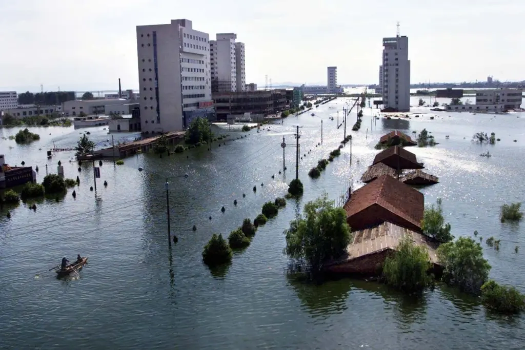
The adverse effects of El Niño can persist even after the event has peaked. For instance, in the summer following the 1997-98 super El Niño, severe rainfall and flooding in China’s heavily populated Yangtze River valley resulted in 3,000 fatalities, displaced 15 million people, and caused $20 billion in economic losses.
An observed positive consequence is the reduced formation of hurricanes off the Caribbean and the east coast of the US during El Niño periods. The amplified atmospheric circulation creates greater wind shear, prompting these storms to dissipate more rapidly rather than developing into major hurricanes.
Influence on Climate Change
If climate change is viewed as a gradual rising tide that steadily increases global temperatures, then El Niño can be likened to a powerful wave that temporarily amplifies these temperatures further. A potent El Niño event could elevate global temperatures by an additional 0.2°C.
The occurrence of El Niño in 2014 contributed to the hottest year on record, with global temperatures briefly surpassing the Paris Agreement’s threshold of 1.5°C for the first time. Many experts anticipate that if a super El Niño materializes, 2027 could set a new global temperature record.
Scaife commented, “Given that we’re already… close to 1.4, it’s quite likely or plausible that 2027 is going to go above the 1.5 threshold. It’s a sign that [global warming is] getting very close to the Paris threshold.”
Future of Super El Niño Events
While El Niño-related temperatures in the central Pacific are warming due to climate change, the long-term average temperatures against which they are compared are also increasing. Consequently, an increase in the frequency or intensity of El Niño temperature anomalies, based on this definition, is not necessarily expected.
In response to this complexity, the US National Weather Service has begun classifying El Niño events based on how much warmer the central Pacific is compared to other tropical regions currently. However, this revised definition has not yet been widely adopted.
Over the past 50 to 60 years, instances of El Niño and its cooler counterpart, La Niña, have become more frequent and extreme. One study suggested that climate change has amplified these temperature swings in the central Pacific by 10 percent. Nevertheless, given the limited and historically less reliable data available over the past 150 years, most scientists remain cautious about definitively attributing the intensification of El Niño to climate change.
Stockdale remarked, “It’s a very tricky question, will El Niño change under climate change. The answer is it probably will.”
It is evident, however, that global warming is exacerbating the impacts of El Niño. Elevated global temperatures lead to increased evaporation from land surfaces and higher moisture content in the atmosphere, which in turn intensifies extreme weather phenomena such as droughts and floods.
Stockdale explained, “We call it an intensification of the hydrological cycle. Because El Niño can cause significant changes in normal precipitation it can be exacerbated by climate change.”